
Carbonate Reservoir Characterization
Instructor: Dr Laura Galluccio (Badley Ashton, UK)
Level: Foundation
CPD Points: 3
Duration: 6 hours
Format: 8 video lectures
Join EAGE or renew your membership to get the best deal!
Certificate
A certificate of attendance will be available upon completion of all course requirements. After the end of the course, your certificate will remain available for download in your Profile page.
Course description
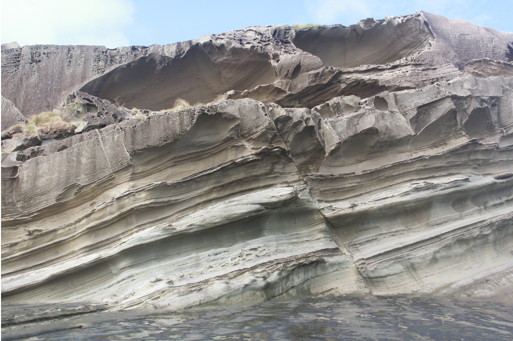
This carbonate reservoir characterisation course focuses on the analysis of carbonate depositional textures and the subsequent diagenetic modifications as the main controls on the pore system evolution, heterogeneity and complexity. The intricate inter-relationship of the depositional and burial history can be unravelled to allow the prediction of reservoir facies, and hence, aid reconstruction and development of three-dimensional reservoir models. This course demonstrates the value of understanding pore system evolution as a part of large-scale volumetric assessments and the development of carbonate reservoirs.
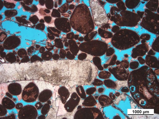
Reservoir quality in carbonate successions is often defined by the storage capacity, flow potential (ie. porosity and permeability respectively, measurements that are often acquired during conventional core analysis) and connectivity of pores (recorded as the pore-throat radius distributions during special core analysis). The interplay between these quantifiable factors (including sample-scale heterogeneities) is inevitably linked to the original depositional characteristics of the carbonate sediments, together with their susceptibility to post-depositional diagenetic alteration, which results in the ultimately complex pore system. Therefore, the classification of individual pore types will be detailed in this course, with their primary depositional or secondary diagenetic origin being discussed in context with sedimentological and stratigraphic models in order to underpin their spatial relationships and potential connectivity. In addition, the characterisation of micrite textures will be discussed to illustrate their impact on the microporosity, factors that are particularly important to consider in tight unconventional reservoirs.
The depositional controls on reservoir properties that will be taken into consideration in this course include the texture, grain size, clay and matrix content as well as the type and quantity of allochems. The relationship between dissolution processes that result in an enhancement of the pore system, cementation processes that reduce the pore volume and the resultant connectivity and fluid flow pathways will be assessed to constrain the dominant diagenetic controls on the reservoir properties. In addition to this, the process of dolomitisation will be scrutinised in order to determine if and how this process enhances and/or reduces reservoir properties.
Integrating the key controls on reservoir quality within the sedimentological framework enables the establishment of a conceptual reservoir architecture model, which can be used to assess and predict the vertical and lateral variations in porosity and permeability at the reservoir and/or field scale. This course outlines how to conceptually build a reservoir architecture model, which in turn can be used to aid reservoir modelling.
Course objectives
Upon completion of the course, participants will be able to:- Identify the different pore types, their interconnectivity and hence the impact on permeability.
- Determine how specific sedimentological parameters and diagenetic process impact reservoir quality.
- Understand sample heterogeneity and its impact on reservoir quality data.
- Upscaling of reservoir quality data to aid prediction at the field scale.
Course outline
The course is organised into three sessions:
Part A: Reservoir quality analysis - what it is and how to approach it
- Definition of reservoir quality
- How to characterise reservoirs
Part B: Pore types and connectivity
- Concepts and definitions
- The carbonate pore type classification(s)
- Permeability and pore-throat radius distributions
- Manipulating reservoir quality data
- Introduction to advanced reservoir quality tools
Part C: Controls on reservoir quality
- Sample heterogeneity
- Sedimentological controls
- Diagenetic controls
- Reservoir architecture construction
Each section will be accompanied by examples from case history exercises.
Participant profile
This course is designed for petroleum geologists, geoscientists, petrophysicists and engineers involved in exploration and production of carbonate plays.
Pre-requisites
Although previous knowledge on carbonate sedimentology is not necessarily required, participants should have some knowledge of geology.
About the instructor
 Laura is one of Badley Ashton's UK-based senior carbonate reservoir geologists with an interest in carbonate petrography and sedimentology. She specialises in sedimentology, diagenesis and reservoir quality characterisation of limestones and dolomites in both conventional and unconventional reservoirs. She has wide experience in the Middle East, the USA, Europe and Africa. The projects she has been involved in cover a wide range of depositional environments from shallow to deeper water carbonates. Laura received his BSc, MSc and PhD at the University of Naples (Italy), with her PhD conducted in conjunction with Shell Italy. As an effective communicator and with a proven track record of excellent client care, past roles include Team Leader of the Carbonate Group, and local Business Manager and Consultant Geologist based in PDO's offices, Muscat. Since her appointment as Regional Manager in August 2017, Laura oversees business activity in the Middle East, Africa and Asia, supported by regional Operations and Portfolio Managers. Laura's other research interests include sedimentology and sequence stratigraphy of ancient and recent carbonate platforms and the characterisation of diagenetic processes affecting carbonate sediments with integration into the regional framework and influence on the pore system. She is currently involved in research on the diagenesis and pore volume assessment of Hyamm Formation in Oman in collaboration with the Ferrara University and Sultan Quaboos University, as well as a project focused on the role of hydrocarbons emplacement for calcite precipitation, in collaboration with Newcastle University. Laura has undertaken teaching of geological mapping, petroleum geology and reservoir quality evaluation at both BSc and MSc levels, while co-supervising a variety of BSc and MSc carbonate research projects.
Registration
Login to register.
By purchasing this course you agree to Terms and Conditions for Registration within EAGE.
EAGE membership for the remainder of the year is included in the non-member fee
Title: Velocities, Imaging, and Waveform Inversion - The Evolution of Characterizing the Earth's Subsurface
Instructor: Dr Ian Frederick Jones
Level: Intermediate
Duration: 6 hours
CPD points: 3
Format: Self-Paced Course, 7 video lectures
Dates: the course is open for registration. After purchasing this course, you will have access to the course material for 12 months. Make sure to complete all the requirements for the achievement of the certificate within this period.
Certificate
A certificate of attendance will be available upon completion of the course. After the end of the course, your certificate will remain available for download in your Profile page.
Short description
This programme deals with velocities, imaging and waveform inversion, thereby concentrating on the origin and nature of the geological complexities that give rise to imaging problems, as well as a physical (rather than mathematical) understanding of the principles behind subsurface parameter estimation techniques, and will also look at some possible future directions.
Participants' profile
The course is designed for practising geoscientists and geoscience students who desire to better understand the principles and limitations of both current and emerging technologies involved in subsurface parameter estimation and imaging, and geoscience students.
Pre-requisites
A general knowledge of geophysics.
About the instructor
 Ian F. Jones received a joint honours BSc in Physics with Geology from the University of Manchester, UK, in 1977, an MSc in Seismology from the University of Western Ontario, Canada, and a PhD in Geophysical Signal Processing from the University of British Columbia, Canada.
After working for ‘Inverse Theory & Applications Inc.’ in Canada for two years, he joined CGG, where for 15 years he was involved in R&D in the London and Paris offices, latterly as manager of the depth imaging research group. In 2000 he joined ION GX Technology, as a Senior Geophysical Advisor in their London office. In 2021 he joined BrightSkies Geoscience as Senior Geophysical Advisor.
His interests include velocity model building and migration, and his most recent activity includes writing the text books: ‘Velocities, Imaging, and Waveform Inversion: the evolution of characterising the Earth’s subsurface’ published by the EAGE in 2018; ‘An Introduction to Velocity Model Building’ published by the EAGE in 2010; and co-editing the SEG Geophysics Reprints series volumes ‘Classics of Elastic Wave Theory’ and also ‘Pre-Stack Depth Migration and Velocity Model Building’, as well as contributing the chapter on model building to the SEG online encyclopaedia.
He has served as an associate editor for the journals ‘Geophysics’ and ‘Geophysical Prospecting’, and teaches the SEG/EAGE/PESGB continuing education course on ‘Velocity Model Building’ and was an external lecturer at the University of Leeds and Imperial College London. Ian was awarded the EAGE’s Anstey Medal in 2003 for “contributions to the depth imaging literature”, made the SEG European Honorary Lecturer in 2012 for “contributions to advancing the science and technology of geophysics”, conducted the 2018-2019 EAGE International Education Tour, and was made an Honorary Life Member by the EAGE in 2018, and received the best paper award for his 2019 First Break tutorial on FWI.
EAGE recognized Ian Jones as Best Instructor of the Year 2025.
By purchasing this course you agree to Terms and Conditions for Registration
EAGE membership for the remainder of the year is included in the non-member fee
Beyond Conventional Seismic Imaging
Instructor: Prof Evgeny Landa
Level: Intermediate
CPD Points: 4
Duration: 8 hours
Format: 12 video lectures
Join EAGE or renew your membership to get the best deal!
| Regular | Student | |
|---|---|---|
| EAGE Bronze/Silver/Gold/Platinum Member | 240 EUR | 110 EUR |
| EAGE Green Member | 365 EUR | 135 EUR |
| Non Member* | 455 EUR | / |
| Education packages | 2 credits | 2 credits |
*EAGE Membership for the remainder of the year is included in the non-member fee
Certificate
A certificate of attendance will be available upon completion of all course requirements. After the end of the course, your certificate will remain available for download in your Profile page.
Course description
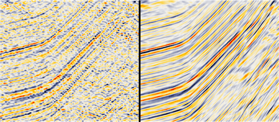
Time images usually provide sufficient information for a variety of subsurface models of moderate complexity and facilitate the estimation of the model for depth migration. Improving the quality of time sections remains the focus of intensive research. In particular, a lot of efforts are directed towards improving the accuracy of moveout correction. The proposed course discusses time imaging procedures such as Multifocusing and Common Reflection Surface when each image trace is constructed by stacking traces which need not belong to the same CMP gather. In this case a new and more general moveout correction is requested. These new methods open a way for reliable wavefield analysis and wavefront parameters estimation. The latest represents a basis for different applications including signal enhancement, velocity model building, statics correction, AVO analysis.
Currently applied seismic processing and imaging are almost exclusively based on seismic reflection. The latest is the response to continuity in the subsurface. At the same time accurate and reliable imaging of small scale geological elements and discontinuities of the subsurface such as faults, unconformity, fractures etc. are a key to improve seismic resolution. In unconventional reservoirs the main objective is detection of fracture corridors. Small scale objects give rise to a diffraction response. Use of seismic diffraction is a rapidly emerging technology which has tremendous potential to reduce exploration and production risks and increase oil and gas recovery. The course integrates elements of the theory of wave propagation, diffraction modeling and imaging, and interpretation. The main objectives are: understanding the role of small and medium scale subsurface objects and elements in forming the total seismic wavefield and using diffraction for imaging.
In the course I introduce a way to look at model-independent seismic imaging using the quantum mechanics concept. Can Feynman’s path-integral idea be used for seismic imaging? We can construct the seismic image by summation over the contributions of elementary signals propagated along a representative sample of possible paths between the source and receiver points. When the velocity model is estimated with uncertainties, a single stationary path does not produce a correctly focused subsurface image. In contrary, quantum imaging uses all possible trajectories accounts for multiple stationary paths and takes into account model uncertainties.
Proposed solutions are usually based on the criterion of the best fit between calculated and observed data. But it is well understood that by itself, a good fit does not guarantee that an inverted model is correct. Seismic inversion may lead to construction of several subsurface models with significantly different geological meaning, all of which fit the observed data equally well. The ill-posedness of seismic inverse problems is fundamental and does not depend on a particular type of algorithm or on the approach underlying the algorithms. In this course, I formulate a number of fundamental questions which should be addressed to make the inverse problems a mature science rather than a set of recipes.
Time Reversal (TR) plays an important role in seismic. It is directly connected to reverse time migration, interferometry and virtual source methods. Recently time reversal is proposed to localize subsurface sources in passive seismic and scatterers in active seismic surveys. Unlike in conventional migration, time reversal approach, in principle, does not require application of imaging condition. Numerical implementation of the time reversal method uses back propagation of the time-reversed recorded wavefield followed by an analysis of its obtained focusing. The physical implementation of TR, called Time Reversal Mirror (TRM), is used in various applications: underwater acoustics, telecommunication, cancer therapy, lithotripsy, nondestructive testing, etc. I demonstrate physical implementation of the TRM in seismic. Results of the field experiment show very promising results. I discuss possible applications of the method in seismic exploration and production.
Course objectives
Upon completion of the course, participants will be able to:
- Understand the role of time and depth imaging withing the general exploration work-flow.
- Understand the differences between several prestack data analysis approaches, in particular CMP, CRS andincrease MF.
- Appreciate importance and potential of seismic diffraction for increase resolution and reliability of seismic imaging.
- Understand the uncertain nature of seismic velocity model and acquaintance to a way of taking the uncertainties into account.
- Understand and admit fundamental problems of seismic inversion including FWI.
Course outline
The course is organised into three sessions:
Part A: Reservoir quality analysis - what it is and how to approach it
- Definition of reservoir quality
- How to characterise reservoirs
- Concepts and definitions
- The carbonate pore type classification(s)
- Permeability and pore-throat radius distributions
- Manipulating reservoir quality data
- Introduction to advanced reservoir quality tools
- Sample heterogeneity
- Sedimentological controls
- Diagenetic controls
- Reservoir architecture construction
Part B: Pore types and connectivity
Part C: Controls on reservoir quality
Each section will be accompanied by examples from case history exercises.
Participant profile
This course is designed for petroleum geologists, geoscientists, petrophysicists and engineers involved in exploration and production of carbonate plays.
Pre-requisites
Although previous knowledge on carbonate sedimentology is not necessarily required, participants should have some knowledge of geology.
About the instructor
 Evgeny Landa obtained his MSc degree in geophysics at Novosibirsk University (1972) and PhD degree in geophysics at Tel Aviv University (1986). He started his carrier in the former Soviet Union, Novosibirsk as a researcher, and senior geophysicist at the Siberian Geophysical Expedition. After immigrating to Israel, he worked at the Geophysical Institute of Israel as a researcher, Head of the R&D group and Head of the Seismic Department (1981—2002). During 2002-2014 he worked as Director of OPERA (Applied Geophysical Research Group) in Pau (France) where he was involved in different aspects of seismic data processing, velocity model building and time and depth imaging. His work on velocity model building by coherency inversion has had a strong impact on today’s seismic depth imaging workflows and forms an important part of the GeoDepth (Paradigm) software package. Recently he is a professor of Tell Aviv University. His research interest involves using non-reflecting energy for increasing seismic resolution and imaging without precise velocity information. He has published more than 60 papers in international journals and his book ‘Beyond Conventional Seismic Imaging’. Evgeny Landa is awarded the EAGE Desiderius Erasmus Award for Lifetime contribution in 2019. He is a member of EAGE and SEG, from which he received the Awards of Best Paper (SEG, Honorary Mentioned, 2005 and 2018) and the EAGE Eotvos Award (2007 and 2009)
By purchasing this course you agree to Terms and Conditions for Registration within EAGE.
EAGE membership for the remainder of the year is included in the non-member fee
Instructor: Dario Grana (University of Wyoming, United States)
Level: Intermediate
CPD Points: 3
Duration: 6 hours
Format: 8 video lectures
Certificate
A certificate of attendance will be available upon completion of all course requirements. After the end of the course, your certificate will remain available for download in your Profile page.
Course description
Reservoir modeling provides a set of techniques to create three-dimensional numerical earth models in terms of elastic, petrophysical and dynamic properties of reservoir rocks. The course focuses on modeling of facies and rock properties from geophysical properties and on quantification of uncertainty of these models. Mathematical and physical models of the reservoir are generally uncertain due to the lack of information, noise in data measurements, approximations and assumptions. Hence, building a reservoir model requires the integration of several disciplines, such as seismic inversion, rock physics, and geostatistics. Seismic inversion aims to transform the measured seismic data into elastic parameters that can be interpreted to determine rock and fluid properties. Rock physics describes a reservoir rock by physical properties such as porosity and compressibility, that affect the seismic response in porous rocks. Rock physics aims to establish relations between these rock and fluid properties and the observed seismic data. Geostatistics aims to provide realistic representations of the reservoirs in terms of structure and spatial distribution of rock and fluid properties by combining geological knowledge and statistical methods. The course covers the fundamental theory of statistical methods for reservoir modeling and uncertainty quantification techniques for reservoir predictions. It is divided into four main parts: fundamentals of statistics, rock physics, geostatistics, and geophysical inverse problems for reservoir characterization. Uncertainty propagation from measured data, through physical models to model predictions will be studied with a focus on seismic data inversion and static reservoir characterization.
Course objectives
After this course, participants will be able to …
1. Generate geostatistical reservoir models
2. Understand physical relations between reservoir parameters and geophysical data
3. Evaluate the uncertainty of model predictions.
Course outline
Chapter 1: Fundamentals of probability and statistics
Chapter 2: Random variables
Chapter 3: Rock physics relations
Chapter 4: Petro-elastic models
Chapter 5: Spatial correlation
Chapter 6: Geostatistical methods
Chapter 7: Seismic
Inversion
Chapter 8: Petrophysical inversion
Participant profile
Geologists and geophysicists in hydrocarbon exploration and production
Researchers in geoscience disciplines
College and graduate students
Pre-requisites
Basic knowledge of geophysics theory and methods
About the instructor
 Dario Grana is an associate professor in the Department of Geology and Geophysics at the University of Wyoming. He received a MS in Mathematics at University of Pavia (Italy) in 2005, a MS in Applied Mathematics at University of Milano Bicocca (Italy) in 2006, and a Ph.D. in Geophysics at Stanford University in 2013. He worked four years at Eni Exploration and Production in Milan. He joined the University of Wyoming in 2013. He is author of the book ‘Seismic Reservoir Modeling’, published by Wiley in 2021. He is the recipient of the 2017 EAGE Van Weelden Award, the 2016 SEG Karcher Award, the 2015 Best Paper Award in Mathematical Geosciences, and the 2014 Eni award with Gary Mavko, Tapan Mukerji, and Jack Dvorkin for “pioneering innovations in theoretical and practical rock physics for seismic reservoir characterization”. His main research interests are rock physics, seismic reservoir characterization, geostatistics, data-assimilation, and inverse problems for subsurface modeling.
By purchasing this course you agree to Terms and Conditions for Registration
EAGE membership for the remainder of the year is included in the non-member fee
Instructor: Ralph Bridle
Level: Foundation
CPD Points: 5
Duration: 9 hours
Format: 9 video lectures
Certificate
A certificate of attendance will be available upon completion of all course requirements. After the end of the course, your certificate will remain available for download in your Profile page.
Course description
Throughout the class there are two persistent themes, the near-surface is complex and any single method does not work everywhere. The presentations start with the geomorphology of the near-surface which is examined, in terms of processes and environments. The physics of raypath propagation is explained. There are assumptions for the whole course: Corrections are not dynamic, physical ground conditions are isotropic and elastic modeling and time domain seismic data processing. A single layer from surface to datum is the initial near-surface model. This is also known as field statics a simple solution supplied by acquisition field crews and often applied as a “first look”. The first augmentation of the basic model is from extra information obtained from uphole survey. The upholes are the only direct measurement of the near-surface depth and velocity layers. The multiple layer model creates improved static corrections over the initial model. Furthermore the uphole interpretation and multiple layer model can adequately define the regional time structure. Refraction statics, of increasing complexity, does provide models which improve the short wavelength focusing of the seismic horizons. The course will describe the theory and assumptions of intercept-time, plus-minus and generalized linear inversion refraction techniques. Reduced travel time analysis is shown to infill the delay time distribution. The modeling culminates with an introduction to refraction tomography. It is recognized that while sophisticated methods improve the focusing of the seismic horizons, there remains challenges to tie them together. A method of inverting time shifts to update a multiple layer model demonstrates a solution of tieing different near-surface static corrections.
Course objectives
After this course, participants will be able to …
1. Judge the geomorphologic and environmental contributions to the complexity of the near-surface. Distinguish the rock physics and wave properties that influence seismic P-wave velocity and propagation.
2. Build single or multiple layer velocity models from interpretations of uphole survey data and additional traveltimes due to sand dunes.
3. Construct delay times and calculate statics from reciprocal time refraction analysis.
4. Differentiate the concepts of common receiver and common emergent point..
5. Demonstrate the concepts of generalized linear inversion, ray tracing, and tomography.
Course outline
Chapter 1: Geomorphology
Chapter 2: Physics of wave propagation
Chapter 3: Single layer velocity model
Chapter 4: Multiple layer modeling
Chapter 5: Arrival time of refracted arrivals
Chapter 6: Intercept-time
refraction statics
Chapter 7: Delay time method and common refractor point
Chapter 8: 8. Tomography
Chapter 9: Model integration
Participant profile
This course is intended for Geophysicists performing seismic data processing requiring knowledge to build near-surface models for static corrections. Interpreters of seismic time domain images who desire to understand the complexity of the near-surface model with respect to data quality.
Pre-requisites
Basic knowledge of structural geology and lithology and basic knowledge of seismic acquisition methods and time domain seismic data processing.
About the instructor
Ralph Bridle (1957) is a retired Geophysical Consultant formerly with Saudi Aramco in the Near Surface Modeling Unit of the Geophysical Data Processing Division in Dhahran, Saudi Arabia. He achieved his Mining BSc(hons) from Camborne School of Mines, Cornwall, England.
Ralph's first experience was in mining, at Shamva gold mine in what was Rhodesia. In 1980 he moved to geophysics and employed by Seismograph Service Ltd (SSL) on acquisition field crews in Pakistan, Bangladesh and Indonesia. Subsequently he transferred to seismic data processing at locations in Libya, Australia, Tunisia, Oman, Somalia and Nigeria. Most of his experience is in data acquisition and processing of seismic data in deserts.
From 1991 until retirement in 2017 Ralph gained more experience in Saudi Aramco’s Near Surface Modeling Unit. His specialty was modeling the near surface for static corrections, modeling multiple layers from uphole surveys, various refraction static methods, tomography and application of geostatistics. Ralph was an enthusiastic mentor and gave numerous in-house classes ranging from one hour to five days. His legacy is found in papers published by SEG and EAGE. In 2014 the SEG awarded him Active Membership for Life. Since 2017 he is resident, with his wife, in the Philippines.
By purchasing this course you agree to Terms and Conditions for Registration
EAGE membership for the remainder of the year is included in the non-member fee